 You don’t have to spend too much time in the Storyofhawaiimuseum.comin Kahului before concluding that curators Bryant Neal and Richard “Buck” Mickelsen love maps. They have maps of Hawaii as it appeared to the earliest European explorers, maps of the islands used by missionaries and maps showing Maui’s land distribution in the 19th century. And now, in anticipation of next year marking the 75th anniversary of the attack on Pearl Harbor, they’ve acquired a number of maps used by Japan in their war planning efforts.
“Maps were important tools for planning war used by both sides,” Neal said in a press release announcing the new exhibit.
On Thursday, Dec. 3, as Neal was getting the new maps organized for display, he walked me through each of them. Many of these are large maps that focus on the Pacific Ocean, full of color and detail of air travel ranges, shipping lanes and natural resources. Many of the maps contain artistic illustrations and photographs. All the maps are in Japanese, and Neal told me he’s still working on getting complete translations.
The first map Neal showed me detailed the bogus “Mukden Incident”–a secret Japanese military operation in 1931 that involved blowing up part of a Japanese railway by Japanese forces, which then used the incident as a pretext to invade and occupy Manchuria. The incident, considered by some historians to be the first act of violence in World War II, led to Japan withdrawing from the League of Nations.
Neal then showed off a Japanese map that was published as a New Years supplement in the January 1930 Osaka Daily News. Titled “Knowledge for the new era,” the map illustrated aviation routes across the Pacific and was ringed with little black and white photos of various famous places and individuals. Given the historical and pop culture aspects of that map, it was clearly designed for a civilian audience.
Not so with the next map Neal showed–a very large 1934 military briefing map of East Asia and the Pacific. “I call this Japan’s ‘Let’s get ready to go to war’ map,” Neal said. It focuses heavily on the respective military forces of Russia, Japan and the United States. Though published seven years before the Pearl Harbor attack, the map’s insets detail Guam, Manila Bay, Hawaii, Pearl Harbor and even San Francisco Bay.
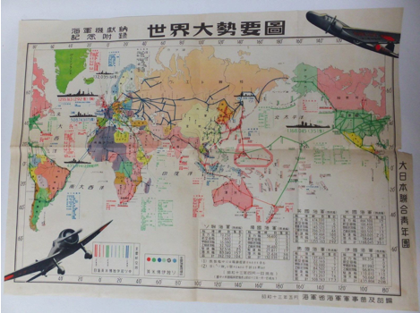
The museum also has a 1938 map published by Japan’s Navy Ministry that shows the various air travel distances between various islands and island chains around the Pacific. The museum also acquired an extremely colorful 1942 map that shows the distribution of strategic materials and resources (magnesium, gold, zinc, oil, etc.) around Southeast Asia.
Then there’s the map, published in March 1942–just three months after the Pearl Harbor attacks–that Neal said is titled “Great East Asia War Mission Accomplished,” which shows Japan’s new holdings in bright red. The museum also acquired a map of the Pacific that was published in Japan just 13 days after the Pearl Harbor attack.
For Neal, the maps make one point abundantly clear–a point he says he many people still don’t really understand. “The Japanese weren’t interested in taking over Hawaii,” he said of the attack on Pearl Harbor. “They wanted the Pacific Fleet.”
For Japan, World War II was supposed to be a short, brilliant assault on Pearl that destroyed our fleet, rendering us helpless in the Pacific and willing to sue for peace. Explaining why things didn’t turn out that way is complex, controversial and the overall purpose of places like the Story of Hawaii Museum.
Neal said the maps will be up and on display by Sunday, Dec. 6. The Story of Hawaii Museum is located in the Queen Kaahumanu Center in Kahului and is open Mon-Sat, 9:30am-9pm and Sun, 9:30am-5pm. For more information, call 808-871-4547 or go to Storyofhawaiimuseum.com.
Photo courtesy Story of Hawaii Museum
Hi, this is a comment.
To get started with moderating, editing, and deleting comments, please visit the Comments screen in the dashboard.
Commenter avatars come from Gravatar.
2UvFaExBWz0W5t2gvQLAi8QkA2X