POLYNESIAN VOYAGERS; THE FIRST PACIFIC VOYAGERS

The story of how Hawai’i found its place on the map in the mid-Pacific is a tale filled with discovery, adventure and conflict.
When European explorers first entered the Pacific, they found that the great ocean had already been mastered by navigators whose nautical skills rivaled their own: the Polynesians. The presence of the Polynesians throughout the ocean’s isles was testimony to an extraordinary seafaring heritage.
Starting from islands near Southeast Asia around 2500 BC the early peoples of the Pacific had island-hopped until they reached the Tonga and Samoa groups about a thousand years later.
When driven from an island by overpopulation, famine or defeat in battle, Polynesians would set off to colonize new lands: sometimes sending exploring parties ahead, sometimes simply trusting fate and their own exceptional abilities to lead them to their destination. They were not always rewarded; many expeditions perished at sea. Such long voyages were planned months in advance.

Even islanders forced into exile by conquering neighbors were given time to build massive double-hulled canoes that could carry scores of people on journeys of eight weeks or more.


Building a voyaging canoe was a community project, supervised by a master craftsman of near-priestly status. Workers shaped large tree trunks into rough hulls and then, with primitive tools of stone, shell and bone, constructed a sturdy sailing vessel measuring 100ft and weighing 10 tons that could cover 150 miles in a day.
The canoes were guided to their destinations by an elite fraternity of navigators, taught from childhood to read nautical information in a host of natural signs. They knew the year – round positions of more than 150 stars and had a vast knowledge of ocean currents, prevailing winds and the habits of migratory birds. When nearing islands beyond the horizon, they could actually smell land, feel echoes in the water from swells bouncing off atolls and see the greenish reflection of forests on the underside of clouds.

Following such clues, the Polynesians crossed 15 million square miles of unknown ocean, and by the 8th century AD(?) they had colonized virtually every habitable speck of land in a vast triangle bound by Hawaii on the north, New Zealand in the southwest and Easter Island to the east.
THE PACIFIC LARGELY UNKNOWN & HAWAII UNMAPPED
Though the Polynesians had been traveling the vast Pacific Ocean for thousands of years, it remained virtually unknown and largely uncharted by European explorers. Balboa first reached the Pacific in 1513. He was followed by Ferdinand Magellan of Portugal, sailing under the Spanish flag who was the first Western navigator to traverse the Pacific, and who gave it the name Pacific, meaning peaceful sea. Many other explorers and ships followed but they all missed Hawaii.

ORTELIUS WORLD (CLICK ON THE MAP ABOVE TO ORDER)

VANDER AA WORLD 1746 (CLICK ON THE MAP ABOVE TO ORDER)
THE EUROPEAN EXPLORERS – CAPT. JAMES COOK
The European discovery of Hawaii occurred on January 18, 1778, when English ships under the command of Captain James Cook sighted the islands of Oahu an Kauai. Cook was conducting one of the great exploratory voyages of history and mapmaking was an integral part of his work.
Discovering new islands was of little consequence if he did not map their locations accurately enough for others to find them later. Foreigners introduced the concept of mapmaking to Hawaii. They made maps of Hawaii to satisfy the needs of maritime, religious, commercial and scientific investigations.

COOK’S GENERAL CHART OF THE PACIFIC 1784 (CLICK ON THE MAP TO ORDER)
A KEY TO THE COLORING ON THE MAP
Cook’s famous chart of the Pacific was published in England in 1784 as a part of the 3rd Voyage Atlas. It was issued uncolored as a copperplate engraving. It is shown here in a colored version. Lines illustrate the track of Cook’s ships -Red for the 1st voyage, yellow for the second, and blue for third. On land the Spanish Empire is colored orange, pink identifies the British Empire, while gray shows Russian lands. French territory is light green, Portuguese is purple and Dutch holdings are yellow.
THE THREE VOYAGES OF CAPT. COOK (1768-1779) MANY IMPORTANT DISCOVERIES IN THE PACIFIC
In three voyages from 1768 – 1779, Cook traversed vast expanses of the Pacific Ocean and made many important discoveries.
He was the first to circumnavigate New Zealand and show it as two separate islands, the first to sail far into the Antarctic region and dispel the idea of a great southern continent. He was the first to map Australia’s coastline. He penetrated farther into the North Pacific looking for a Northwest Passage and mapped more of this region than any other explorer of his era. Perhaps his most significant finding was to reliably locate and map the Hawaiian chain which had been missed by many earlier navigators in the Pacific
The first great map to identify what were called the “New Discoveries” was Capt. James Cook’s huge General Chart, published London in 1784 as part of his great third voyage atlas. Most people know Cook’s name, but what they don’t usually realize is how much of the Pacific was first charted by this English navigator during his three famous 18th-century expeditions.

THIS IS THE FIRST PRINTED MAP OF HAWAII. IT WAS ISSUED IN 1784 NOTE THE PHONETIC SPELLING OF THE ISLAND NAMES. THIS IS A LATER ENGLISH EDITION BY HOGG PUBLISHED IN 1795. THE CIRCLE AROUND THE TITLE DIFFERENTIATES IT FROM THE 1ST EDITION. (CLICK ON THE MAP TO ORDER)
COOK REACHES HAWAII ON HIS 3RD VOYAGE
It was on his third voyage that Cook became the first Western expedition to visit Hawaii in his two ships, the Resolution and the Discovery. His staff on the Resolution included John Gore, James King and John Williamson as lieutenants and a master named William Bligh (the same Bligh who would captain the mutinous Bounty.
His companion ship, the Discovery, was commanded by Captain James Clerke with George Vancouver a midshipman. Vancouver would later command his own celebrated voyages of Pacific discovery. Also aboard was the artist Joseph Webber whose drawings and paintings formed the basis for the prints published in the report of the expedition and were some of the first Western views of many of the people of the Pacific. The noted botanist Joseph Banks was also a member of the party.
They set sail from England on July 12th, 1776. Many months later on January 18 1778, two mountainous land masses were sighted. Cook was making his last major discovery – The Hawaiian Islands. He named them the Sandwich Islands after his friend and patron the Earl of Sandwich.

AN INLAND VIEW OF ATOOI. FIRST RECORDED VIEW OF THE ISLAND OF KAUAI PUBLISHED 1784. (CLICK ON THE MAP TO ORDER)
Cook anchored at Waimea on Kauai. As he landed, the Hawaiians fell to the ground before him. He was being received with the same respect paid to the half-divine Hawaiian Kings or ali’i moku. The Hawaiians were friendly, hospitable and honest.
On February 2, 1778 the ships set out for the North Pacific looking for the Northwest Passage. After many adventures they turned south again and reached the Hawaiian Islands on November 26. For two months they lingered in Hawaiian waters without landing. Whenever their ships neared the islands, however, the native welcome was exuberant.

THE FIRST RECORDED VIEW OF EUROPEANS ON THE ISLAND OF HAWAII (CLICK ON THE MAP TO ORDER)
On January 17, 1779 the ship finally anchored in Kealakekua Bay on the Big Island of Hawaii where fifteen hundred canoes carrying an estimated 9,000 islanders came out to meet them. For the next few days, visits were made by royal personages who brought valuable gifts to Cook and his men. Everything seemed well.
Within a week, however, the warm friendly hospitality turned into cold hostility. Whether the priests believed their power was being overshadowed by the new intruder or whether Cook’s crew had simply worn out their welcome, we will never know. Cook sensed the change of mood and ordered his tents on the beach to be dismantled and planned to sail to Kamchatka on the east coast of Asia. They left on February 4 with an affectionate farewell from the islanders.
Within six days, Cook was back again. A storm had broken a mast and it needed repairing before further sailing could be done. No warm reception awaited them this time.
The Death of Cook on the Island of Hawaii is one of the most memorable scenes in the history of Pacific exploration. This view is by John Webber is best known. Over the years the scene was drawn by many artists of varying abilities. It was also reproduced in many sizes and in many languages .Many of the details are fanciful.
DEATH OF COOK
Cook was killed on February 14, 1779 at Kealakekua Bay on the Big Island, the very place he had first received such a warm welcome. The cause of his death was a dispute over a missing boat. Cook planned to go ashore and take a chief hostage until the boat was returned. This strategy had served him well in the past, but on this occasion the family rushed forward crying and begging them to release their captive.

THE FIRST PRINTED MAP OF HAWAII
The first map of Hawai’i is often credited to Captain James Cook because he was in charge of the expedition that produced it. The official map is attributed to Lt. Henry Roberts, who prepared for publication all of the maps appearing in the three-volume narrative detailing the adventures of Cook’s final voyage.
The large inset of “Karakakooa Bay” represents the Kealakekua Bay on the island of Hawaii the scene of Cook’s first landing and also the scene of his death. The tracks of Cook’s ships are shown by the dashed and solid lines. The longitudes in the bottom and top borders are numbered continuously in an eastward direction from Greenwich; the longitudes shown on this map can be converted to the modern format by subtracting the value of 360.
Although best known for his later involvement in the famous mutiny on the Bounty, Bligh earlier sailed with Cook. He was an outstanding seaman and accomplished chart maker. Only twenty-one when selected by Cook as master for his flagship, the Resolution, Bligh performed many critical duties aboard ship, one of which was to assist in the making of the charts and harbor plans. After the publication of the official narrative of Cook’s third voyage, Bligh privately challenged the assertion that Roberts drew the maps that accompanied the volumes, claiming credit himself for many of the maps, particularly the plan of Kealakekua Bay and much of the larger map of the “Sandwich Islands.”

A WORD ABOUT SPELLING & THE HAWAIIAN LANGUAGE
THE COOK CHART OF HAWAII CLEARLY SHOWS THE PHONETIC SPELLING USED BY CAPTAIN COOK WHEN ATTEMPTING TO SPELL THE NAMES OF THE ISLANDS.
Until the arrival of American missionaries in the early 19th century Hawaii had no written or printed language. Everything until that time was transmitted orally including history through chants, stories and legends.
When Cook arrived he wrote down the names based on what he heard the natives call each of the using a phonetic approximation Cook didn’t rename the islands but spelled what he heard; most authorities believe that these are the original Hawaiian island names. When saying the phonetic spelling of the island names pronounce T as K and R as L and sound all vowels separately.
Oneehow – Niihau; Atooi – Kauai; Woahoo – Oahu; Ranai = Lanai; Mowee = Maui; Morotoi = Molokai; Owhyhee – Hawaii; Tahoorawa – Kahoolawe.
LATER EUROPEAN EXPLORERS

CHART OF THE SANDWICH ISLANDS BY JEAN-FRANCOIS LA PEROUSE 1786 (CLICK ON THE MAP TO ORDER)
THE SECOND EUROPEAN EXPLORER TO VISIT HAWAII AND THE FIRST TO COME ASHORE ON THE ISLAND OF MAUI WAS THE FRENCH EXPLORER JEAN FRANCOIS LA PEROUSE.
La Perouse visited Hawaii and oversaw the compilation of this chart published in 1786. His extremely short stay, however, precluded his hydrographer, Bernizet, from completing the charting of shorelines which were missed during Cook’s voyage.
La Perouse touched only at the island of Maui, consequently most of this map was taken from Roberts’ earlier chart of Hawaii. Bernizet’s miscalculation of the east – west distance for the Big Island and a new mapping of the south coast of Maui are the two significant improvements this explorer put on the map from his brief 48 hour visit.

CHART OF THE SANDWICH ISLANDS GEORGE VANCOUVER, JOSEPH BAKER, 1792 – 1794 PUBLISHED 1799 (CLICK ON THE MAP TO ORDER)
GEORGE VANCOUVER
The third major expedition to Hawaii was led by the English explorer Capt. George Vancouver, who visited the islands between 1792 and 1794. He had traveled to the Pacific with Capt. Cook on both the 2nd and 3rd voyages. Vancouver was one of the most qualified and experienced English officers. He sailed to the Pacific with the specific purpose of settling a dispute in Nootka Sound and finishing what Cook had started …searching for the elusive Northwest Passage.
His was the only expedition to completely circumnavigate all the islands of the chain. Vancouver’s voyage resulted in the first published map of Hawaii depicting the islands in their entirety. This landmark work, credited to Joseph Baker, is one of the most significant maps in Hawaiian history.
The Vancouver – Baker chart remained the basic map of Hawai’i for nearly 80 years, though some of the errors found were corrected by later map makers.
Additionally, Vancouver introduced cattle to Hawaii and is responsible for a political relationship between Hawaii and England which led the Kingdom of Hawaii to make its own flag and to insert the Union Jack in the upper corner. Hawaii was never under British rule, though it was for some years a British protectorate.
The flag of Hawaii originated with the Hawaiian Kingdom and continues to this day as a state flag. It incorporates elements of the British Union Jack and the American Stars and Stripes.
THE HAWAIIAN FLAG
La Perouse visited Hawaii and oversaw the compilation of this chart published in 1786. His extremely short stay, however, precluded his hydrographer, Bernizet, from completing the charting of shorelines which were missed during Cook’s voyage.
La Perouse touched only at the island of Maui, consequently most of this map was taken from Roberts’ earlier chart of Hawaii. Bernizet’s miscalculation of the east – west distance for the Big Island and a new mapping of the south coast of Maui are the two significant improvements this explorer put on the map from his brief 48 hour visit.

The flag of Hawaii originated with the Hawaiian Kingdom and continues to this day as a state flag. It incorporates elements of the British Union Jack and the American Stars and Stripes
Hawaii began as an independent kingdom. It became a protectorate, republic, territory and finally the 50th state of the United States. It is the only state flag of the United States to have been flown under so many forms of government and the only American flag to feature the Union Flag of the United Kingdom, as part of its design. This is a holdover from the period 1794-to 1843 when Hawaii was a British protectorate.
The field of the flag is composed of eight red, white and blue horizontal stripes symbolizing the eight major islands (Niihau, Kauai, Oahu, Molokai, Lanai, Maui Kahoolawe and the Big Island of Hawaii). A ninth stripe was once included representing the island of Nihoa.
There are various accounts of the early history of the flag. One relates how King Kamehameha I flew a British flag, probably a Red Ensign, given to him by British explorer Captain George Vancouver as a token of friendship with King George III.
Subsequent visits reported seeing the flag flying from places of honor. An adviser to Kamehameha noted that the British flag could draw Hawaii into international conflict, as his kingdom might be seen as an ally of the United Kingdom, and he subsequently lowered it.
Another story reports that in order to placate American interests during the War of 1812, a flag of the United States was raised over the king’s home only to be removed when British officers in the court of Kamehameha strongly objected to it. This version would explain why the resulting flag deliberately combined the flags of both countries. In 1816, Kamehameha commissioned his own flag to avoid conflict and the current flag of Hawaii was born. It continues in use today as the flag of the 50th state.
LE ISOLE DI SANDWICH – GIOVANNI CASSINI 1798 THIS 18TH CENTURY ITALIAN MAP IS NOTABLE FOR ITS DECORATIVE AND FANCIFUL CARTOUCHE DEPICTING THE “DEATH OF COOK” IN A HIGHLY UNUSUAL SCENE SHOWING NATIVE WHO SEEM TO BE DRESSED AS AMERICAN (CLICK ON THE MAP TO ORDER)
Published in 1798, one of the first decorative maps of early Hawai’i is “Le Isole di Sandwich,” by Giovanni Cassini. The map is based on Cook’s chart however, Cassini, inspired by John Webber’s engraving, added his version of the Death of Cook to the cartouche.
Because the artist had little knowledge of Polynesians or English officers’ uniforms, he used his imagination and placed Cook’s men in Italian officers’ uniforms and depicted a warlike band of Indians (who appear to be much like Native Americans) in feathered headdress. They are shown stabbing the good captain in the back.
This map clearly shows the phonetic spelling used by Captain Cook when attempting to spell the names of the islands.
MISSIONARIES AND MAPS OF HAWAII

NA MOKUPUNI O HAWAII NEI BY SAMUEL KALAMA. ONE OF THE FIRST MAPS MADE IN HAWAII, IN HAWAIIAN BY A NATIVE HAWAIIAN ENGRAVER WHO HAD LEARNED HIS CRAFT FROM AMERICAN MISSIONARIES. IT WAS PUBLISHED IN 1838. (CLICK ON THE MAP TO ORDER)
Protestant missionaries from the United States arrived in Hawaii on March 30, 1820, after a five-month voyage from Boston aboard the Thaddeus. The “Pioneer Company” of missionaries brought the institution of Christianity to the islands. They arrived at a very fortunate time, just weeks after the Hawaiians had overthrown their old system of beliefs which had many rituals the worship of idols and prohibitions known as kapu.
The missionaries were practical people. They believed that teaching the native population to read and write was necessary was to further their Christian goals. To this end schools were built, teachers trained, and printing presses established. The intent was to make the Hawaiians capable of reading the Bible. As their schools progressed a need arose for books and maps.
The missionaries responded first by hand copying them from various sources. Later, the art of copperplate engraving and printing was taught to Hawaiian students so that maps could be engraved and printed in their native language. These maps, now extremely rare, were provided to schools throughout the islands.
The most significant development in the effort to provide maps for the geographic education of the Hawaiians began in the mid-1830s at the Lahainaluna an early missionary school on Maui. The task of building and operating the school was assigned to Lorrin Andrews, a missionary who had arrived in 1828 and served in the town of Lahaina. Andrews was educated at Jefferson College in Pennsylvania and at the Princeton Theological Seminary. He established a press at Lahainaluna to satisfy the demand for educational materials.
The early presses printed literally millions of pages including the first newspaper in the islands, Ka Lama Hawaii. Andrews also translated and published numerous school books including religious treatises, geographies, and mathematical texts.
This Pacific centered double hemisphere map was produced at Lahainaluna on the island of Maui by Hawaiian students. The diagram on the right of the map shows the relative heights of major mountains.
MISSIONARY MAP SHOWS HAWAII IN THE CENTER OF THE WORLD

PALAPALA HONUA 1839 – KALAMA & KEPHONI (CLICK ON THE MAP TO ORDER)
Several students at the school did the actual drawing and engraving of the maps. Two of the most prolific were Kalama and Kapeau. Kalama later became one of the best surveyors in the islands, and Kapeau eventually became Governor of the island of Hawaii. A young boy who was not a student, Kepohoni (his name is the Hawaiian word for Cape Horn) did the largest number.
The maps were essentially copies of maps from popular school atlases. Since they were intended for the use of the Hawaiian students, the place names were given either in the Hawaiian form of the name or in a modified transcription in which vowels were added so the foreign words could be pronounced in the Hawaiian style.
This Hawaiian language version of double hemisphere world map was engraved to aid Hawaiian students in learning global geography. It represents a joint effort by Kalama and Kepohoni. Several students at the Lahainaluna did the actual drawing and engraving of the maps. This map offers a rare Pacific centric world view placing Hawaii in the middle of the map. Most school maps of this period focused on the Atlantic Ocean and showed Hawaii as a tiny dot far off to the side.
THE U.S. EXPLORING EXPEDITION, LT. CHARLES WILKES 1840 – 1841

PALAPALA HONUA 1839 – KALAMA & KEPHONI (CLICK ON THE MAP TO ORDER)
Several students at the school did the actual drawing and engraving of the maps. Two of the most prolific were Kalama and Kapeau. Kalama later became one of the best surveyors in the islands, and Kapeau eventually became Governor of the island of Hawaii. A young boy who was not a student, Kepohoni (his name is the Hawaiian word for Cape Horn) did the largest number.
The maps were essentially copies of maps from popular school atlases. Since they were intended for the use of the Hawaiian students, the place names were given either in the Hawaiian form of the name or in a modified transcription in which vowels were added so the foreign words could be pronounced in the Hawaiian style.
This Hawaiian language version of double hemisphere world map was engraved to aid Hawaiian students in learning global geography. It represents a joint effort by Kalama and Kepohoni. Several students at the Lahainaluna did the actual drawing and engraving of the maps. This map offers a rare Pacific centric world view placing Hawaii in the middle of the map. Most school maps of this period focused on the Atlantic Ocean and showed Hawaii as a tiny dot far off to the side.
MORE MISSIONARY MAPS

MAP OF THE HAWAIIAN ISLANDS, LAHAINALUNA, 1843 SHELDON DIBBLE (CLICK ON THE MAP TO ORDER)
Hiram Bingham was one of the early Christian missionaries to Hawaii. The task of teaching industry and Christian values natives was a big one, and so Bingham sent for reinforcements who arrived in ( 1828 or 1831?) the form of the newlyweds Rev. and Mrs. Sheldon Dibble.
During Dibble’s Hawaii tenure, he taught at the missionary school in Lahainaluna on Maui. He played a key role in recording and saving the oral history of Hawaii. He was the author of the first written history, “A History of the Sandwich Islands,” in 1834 (1843??) , which included the Lahainaluna map, engraved and printed by Dibble’s students from copper sheeting. The maps printed at Lahainaluna were some of the first maps of Hawaii to be printed in Hawaii by Hawaiians.

HAWAIIAN ISLANDS, 1848(7 HIRAM BINGHAM (CLICK ON TEH MAP TO ORDER)
Hiram Bingham and his wife arrived on the Island of Hawaii in 1820 and then sailed on to Honolulu. Bingham played a key role in the translating and creation of the spelling system for the Hawaiian language. He also translated several books of the Bible into Hawaiian.His memoir “A Residence of Twenty-One Years in the Sandwich Islands” was published in 1847 (check the date for first printing). in which this? detailed wood block map appeared. The map was one of the first to show the island names spelled utilizing the missionary inspired 12 letter alphabet.
HAWAII IN THE MID-19TH CENTURY – AN ISLAND KINGDOM

THE HAWAIIAN ARCHIPELAGO 1862 BY MANLEY HOPKINS SHOWS A PACIFIC CENTERED VIEW OF HAWAII, AS WELL AS ITS FLAG. (CLICK ON THE MAP TO ORDER)
By the mid-19th century, Hawaii was firmly established on the maps of the world, but mapping of its own geographic features was entirely another story.
This map, which first appeared in 1862 shows a finely detailed depiction of the eight major Hawaiian Islands. The inset shows Hawaii from a Pacific centric perspective and accurately locates it in the Pacific Ocean, approximately 21 degrees north of the equator, 2100 miles from San Francisco, its’ closest neighbor, 2600 miles north of Tahiti, on the same longitude as Mexico City and Hong Kong and 3900 miles from Japan. It is one of the first maps to show the flag of the Kingdom of Hawaii.
The map appeared in Hawaii: The Past, Present, and Future of Its Island-Kingdom by Manley Hopkins, the British Consul General to the Kingdom of Hawaii. The author is probably best known as the father of the famous English poet, Gerald Manley Hopkins.
NO PRIVATE OWNERSHIP OF LAND IN THE KINGDOM
In old Hawaii there was no diverse ownership of land, the kings of the Kamehameha dynasty owned it all. They awarded custody of lands to their loyal chiefs-known as ali’i. Island kingdoms (mokupuni) were divided into districts (moku) which were further parceled into minor chiefdoms (ahupua’a). Parcels claimed by the royalty but where ordinary native people lived and worked were known as kuleana lands.
Typically ahupua’a were in a roughly triangular shape extending from the high forested mountains to offshore fishing grounds at sea level with the point at the mountain and the widest part at the shore. These pie shaped pieces provided the residents with access to the resources of all elevations without crossing borders.
Within each ahupua’a were ‘ili, or smaller holdings, each typically worked by one extended family. Throughout the Hawaiian Islands, the names of moku and some ahupua’a are preserved to this day as geographic areas.
Even lands controlled by the chiefly class did not pass by inheritance; what the crown gave, it could also take back or reassign to others. Because land was immortal and humans mortal, the idea that humans could own land was something that neither the kings or the commoners understood. Their attitude was one of territorial caretaking rather than ownership. It was said that land could not belong to man because man belonged to the land.
In his 1840 Constitution of the Kingdom of Hawaii, Kamehameha III stated that although his father was founder of the kingdom, the land “was not his own private property. It belonged to the chiefs and people in common, of whom Kamehameha I was the head, and had the management of the landed property.”
THE GREAT MAHELE OF 1848
As the century progressed people of many nationalities settled in Hawaii and as the Western population grew it and became influential and out spoken in calling for an end to the semi-feudal land ownership system.
In 1848 Kamehameha III and 245 chiefs met to divide the Hawaii lands among themselves. They hoped to have a land system that gave a wider ownership base but still kept Hawaiian lands out of the hands of foreign owners. Sixty percent of the land was allocated as the Hawaiian crown lands. Thirty-nine percent was given to the chiefs and the remaining one percent was to go to the common people. This land division was called the Great Mahele.
Two years later in 1850 two more important laws were passed. One allowed aliens to own land in the Kingdom, and the other permitted Hawaiians who had formerly worked kuleana lands to claim it as their own homesteads if they followed certain procedures. Unfortunately very few Hawaiians understood the new land ownership system or the real value of the lands. They were persuaded that if they allowed foreign ownership that it would encourage foreign investment, which indeed it did. Large tracts of land were soon purchased and leased to non-Hawaiians mainly for agricultural purposes and the framework of what became Hawaii’s sugar and pineapple plantation system was laid.
Because Hawaiians were not inclined to work on the plantations the owners of these vast operations imported foreign labor from Japan, China, the Philippines and Canary Islands to work in the fields. Thus the framework of a new power system primarily owned by American merchants was established and the composition of the population changed drastically as wave after wave of foreign workers arrived in Hawaii
THE HAWAIIAN GOVERNMENT SURVEY
 During the Kingdom of Hawai’i legislative session of 1868, Curtis Jere Lyons, the representative from North Kohala, addressed the subject of the real estate problem facing the Kingdom of Hawaii. Lyons proposed that an official government surveyor be hired to try to resolve the numerous inaccuracies introduced by the insufficient surveying during the Mahele.
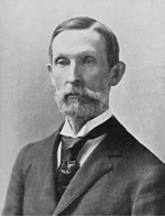
William DeWitt Alexander was born in Honolulu on April 2, 1833 a little less than a year after his parents, William Patterson and Mary Ann McKinney Alexander arrived in Hawaii with a company of Protestant missionaries under the auspices of American Board of Commissioners for Foreign Missions (ABCFM) based in Boston. After a brief stint in the Marquesas Islands and an unsuccessful attempt to establish a mission station, the family was transferred to Lahainaluna, Maui in 1843. Nine year old William was sent to Honolulu where he was placed in the first class of Punahou School.
There he immediately demonstrated his intellectual abilities and was frequently called on to instruct his peers in Latin. In 1849 he completed his course of study at Punahou and sailed around Cape Horn to the United States to attend Yale University in 1850. Alexander, despite illness, excelled at Yale. He was selected Phi Beta Kappa and joined the elite Skull and Bones club.
He graduated in 1855 with honors. After a year as headmaster at a secondary school in Indiana, he went to earn a masters degree from Yale in 1858. A class in surveying during his junior year at Yale gave Alexander the basic skills to create one of the greatest maps of Haleakala ever created.
Alexander’s map of Haleakala was the first to document how dramatically magnetic north can vary within a fairly short distance. It demonstrated Alexander’s mastery of the basic principles needed to run a surveying operation. Indeed, it was probably the most scientific land survey of Hawaii to that date.
In the fall of 1870, W.D. Alexander was formally appointed Surveyor General of the Kingdom of Hawaii. Despite the challenges of creating a new surveying and mapping agency from scratch, Alexander had a clear vision for the agency which was described in a letter to his superior April 4, 1874 where he states, “Our survey differs from similar European operations in not being military or a purely scientific and topographical survey, but a survey of the landed property of the kingdom. It, however, resembles those surveys and the U.S. Coast Survey in being founded on accurate trigonometrical and astronomical measurements.”
At the time of the establishment of the Hawaiian Government Survey, the United States had not yet created the U.S. Geological Survey, which would become America’s first truly national mapping agency. Although mapping was an important component of the General Land Office, it was limited to the portions of the country using the Public Land Survey System.
The oldest mapping operation in America, the Coast Survey, charted only the shorelines and nearby waters to aid navigators. The only well-developed mapping agencies in existence were in Europe.
Yet Alexander recognized that those agencies were not good models for Hawaii. As he noted, European agencies were producing detailed maps for military purposes. With no history of warfare with neighboring nations, Hawaii had no need to produce maps to plan defensive systems or launch offensive campaigns.
Scientific mapping especially in the form of geologic mapping was also taking hold in Europe, but Hawaii with virtually no mineral resources, had no need of mapping to assist a mining industry. Though several nations in Europe were developing large-scale topographic mapping, the cost of such detailed mapping was more than Hawaii could afford.
Alexander was thus steered a course that fit within a limited budget and would contribute directly to the welfare of the nation. He was intent on mapping the lands and documenting the boundaries of the property that constituted the Kingdom of Hawaii. Alexander thought such a survey was much needed in order to determine what Government lands remained unsold.
Alexander also warned that there had never been a uniform system of surveying the kuleanas. The work had been done in a hasty and fragmentary manner by incompetent surveyors. He suggested that both, for the good of the people and the information of the government to make a thorough examination of all the original surveys.
Upon completion he suggested marking the principal corners in a permanent manner. He further argued that the private surveying profession would also benefit from the agency’s work. The government district maps would provide future surveyors with clear land coordinates.
Alexander also felt that all information in the Survey Office should be accessible under proper regulations to members of the profession, and in return copies of all boundary surveys both public and private should be deposited with the office.
Alexander thought he should represent an exact delineation for the shore line and the more important topographical features of the country. (However, he did not propose to make a regular topographical survey of the country or to run lines of level, except for some special object; although it is intended to measure the heights of all the prominent stations.) He also declined to make a general hydrographical survey of the depth of water and the character of the bottom of the sea around each island. There were numerous reasons Hawaii needed a government survey agency and it was quite fortunate to find a man with such a clear well-defined vision of what the agency could contribute to government and society. (Moffatt – Fitzpatrick quote)
THE KINGDOM EXHIBITS ITS MAP AT THE AMERICAN CENTENNIAL 1876

The first major map published by the Hawaiian Government Survey was prepared especially for the Hawaiian exhibit at the International Exhibition of Arts, Manufactures and Products of the Soil and Mine, which opened in Philadelphia in the spring of 1876, celebrating the 100th anniversary of American independence, it was more commonly known as the Centennial Exhibition.
In size, design, and execution it compared favorably with the best wall maps displayed there. Its design and scope were undoubtedly decided by Surveyor General, W.D. Alexander, with the manuscript compiled by Curtis Lyons, who was responsible for most of the drafting for the government survey at that time. H.Giles is credited with the final execution.
At a scale of 30,000 feet to the inch, the map said Alexander, “will do this country no little credit at the Centennial.” Alexander also noted that the map was an impressive four feet high by six feet wide. As it turned out, however, the printed map was published at approximately thirty-five inches in height by fifty-five inches in width, or 75 percent of the actual size Alexander had intended, a reduction that may have been made for reasons of cost or expediency. Certainly publishing a map at the intended size would have been a monumental task; even at the final size it was a significantly large map for the time period.
The change in size also changed the scale, from 30,000 feet to the inch, or 1:360,000 to 40,000 feet to the inch, or 1:480,000. Regrettably, when the scale statement was printed, it kept Alexander’s planned scale of 30,000 feet to the inch rather than showing the actual scale. Such an error would have been difficult to catch without having a representative of the Hawaiian Government Survey in attendance at the printer’s plant. As the agency’s first formal production, the map remains a remarkable achievement despite the error.
An examination of the Centennial map reveals that it deliberately departs from the policy and intent of the Hawaiian Government Survey. Unlike the agency’s other maps, it is not a map of the landed property of the kingdom and was not meant for a technical audience.
Alexander thus chose to highlight the main topographical features rather than information on land titles or land divisions. Those features are more accurately placed than ever before, and the kingdom’s towns and major plantations and ranches are named.
Alexander took extra pains to portray information not normally found on a map of this type, by indicating the extent of many of the major forested areas on Hawaii and Maui and delineating historic lava flows. However, at this stage in the life of the government survey, only Oahu had been completely surveyed and was thus correctly drawn. In the coming years, the agency would improve the shape of the individual islands as accurate surveys were completed, but the Centennial map remained the basic map of the Kingdom until 1901.
The map’s design contained a number of interesting aspects, the compass cartouche, for instance, appears to link Hawai’i with the American mainland. Considering the map’s debut at a centennial celebration for the United States, one might wonder if this placement was intentional. Also notable are the insets in the lower left corner of plan views of Haleakala, Moku’aweoweo, and Kilauea. Since the map held a prominent place in the Hawai’i exhibit at the exposition, the inclusion of these craters reflects the pride Hawaiians took in their volcanoes.
By highlighting volcanoes and lava flows, the kingdom may have been playing to the nascent tourist industry. It is interesting to note, for example, that all the crater plans are drawn at the same scale of approximately one mile to the inch. On either side of the map’s title is a representation of the main building of the exposition drawn at the same scale. At more than a quarter mile long, the exposition building was monumental for its time. The judicious placement of the crater insets seems almost a subtle taunt from across the Pacific; “If you think this building is grand you should see our volcanoes”
MAPS OF INDIVIDUAL ISLANDS ONGOING
As the Maui surveys were completed, Frank S. Dodge started to assemble them into a general map of the island. He began the task in 1879 and finished late in 1885, following completion of survey work on West Maui that was done in large part by Sereno E. Bishop. The map was sent to Julius Bien in New York, who printed five hundred copies in the spring of 1886. The map shows the ancient districts, or moku, which have since been realigned on Maui, as well as the ahupua’a and the ili, along with the grants and awards by which they were held.

MAUI BY W.D. ALEXANDER AND E. S. DODGE 1885 (CLICK ON THE MAP TO ORDER)
In addition to the standard colors of yellow for Crown land green for government lands, Dodge employed several other colors to cope with the land complexities of Maui. For example, an unusual land in Hawaii is the ili kupono of Wailuku, shown in pink and covering the north half of the isthmus that connects the two halves of the island. An ili kupono was an ili that was independent of any ahupua’a. Wailuku was purchased by Claus Spreckels in 1882 and formed a major component of his sugar empire in Hawaii.
Dodge’s map of Maui, like the Lyons – Covington map of Oahu is a tribute to the skill and dedication of the staff of the Hawaiian Government Survey. Two sections of this map are worth examining in detail. The northeastern portion of East Maui, famed for its twisting road that makes even hardy travelers of today carsick, is one of the most rugged pieces of land anywhere in the United States. Its deeply incised, steeply falling valleys are difficult passage for the strongest of hikers. Yet by 1883 the courses of most of the streams and the ridges separating them had been mapped with considerable accuracy. The central portion of West Maui is another rugged and wet piece of terrain that required fortitude as well as skill to map.
The north end of the original 1871 baseline can be seen just east of Kahului, and the south base is located halfway across the isthmus in a southwesterly direction. This was the first baseline established by the Hawaiian Government Survey, and the accuracy of the coastline of Maui and all of its internal features on this map can be traced back to the painstaking effort of Alexander and his staff.

HAWAIIAN ISLANDS BY S.B. LINTON AND D.W. GARRIGUES, FEBRUARY, 1893 PUBLISHED ONE MONTH AFTER THE OVERTHROW OF THE MONARCHY SUPPORTED THE POPULAR IDEA THAT HAWAII WAS AT THE CROSSROADS OF THE PACIFIC AND STRATEGICALLY LOCATED FOR TRADE. (CLICK ON THE MAP TO ORDER)
OVERTHROW OF THE KINGDOM, ANNEXATION AND MAPS
Despite the high caliber of mapping produced by the Hawaiian Government Survey during the late 1800’s, commonly available maps of the world or of the Pacific Ocean presented a serious distortion of Hawaii’s position, particularly in relation to Asia.
The popular phrase “Hawaii, crossroads of the Pacific” is because of the many maps that suggest that Hawaii lies at the intersection of the most direct trade and travel routes between Asia and the Americas. At least until recent times, this was a false assumption. The very fact that so many of the early explorers failed to find the Hawaiian Islands indicates that it was not on the main sea routes of earlier times.
But leading up to the overthrow of the Kingdom by American mercantile interests in 1893 it became popular to put an emphasis on the supposed “strategic” defensive and commercial positioning of Hawaii. This was one of several factors that contributed to the American take over and encouraged early expansionist ideas.
New found opportunity for financially successful commercial ventures may have also been a catalyst. The Reciprocity Treaty of 1876 caused one of the major changes of the use of Hawaiian lands. This agreement allowed Hawaiian Sugar to enter the United States without tariffs which encouraged expansion of sugar plantations, consequently creating an exportable cash crop to.
In January 1893 the Queen Liliuokalani was overthrown and the Republic of Hawaii was formed. The following year, the Republic of Hawaii offered to be annexed by the United States. After an investigation of the overthrow, the Senate voted to accept the annexation. However, President Grover Cleveland vetoed the annexation offer, and since there were not enough votes to override the veto, the annexation offer died.
At the time of these hearings, a 43 page document was printed by the U.S. Government Printing Office for the Department of the Army, entitled The Hawaiian Islands; Report on the Physical Features, Ports of landing, Supplies, Climate, Diseases, Etc. Compiled from the Best Available Sources for the Information of the Army. The first page of the report says. “The strategic value of the islands and their geographical position are indicated on chart titled Naval Chart of the Pacific and Western Atlantic”.
During this period the implied strategic value of the Hawaiian Islands is often indicated by the use of straight lines representing the sailing routes from the Pacific Northwest to Australia and New Zealand and from Panama to major ports in Asia, all leading to Hawaii. These maps clearly intended to show that all major trade routes in the Pacific passed through or very near Hawaii.
The authors of the report to Congress were far from alone in their apparent belief in Hawaii’s value to the United States. Many Mainland Americans ardently supported the idea of Hawaiian annexation and used maps to further their views.
Philadelphia publishers Linton & Garragues issued a map in February 1893 one month after the overthrow that fits this mold. Signed by some of the leading men in the take over it contained an inflammatory text depicting the native people as heathens and baby eaters. It also shows the arrows seeming to place Hawaii at the hub of the Pacific.
In 1898 the United States entered into the Spanish-American War, attacking and capturing the Philippines and Guam, two Spanish possessions in the Pacific Ocean. At this point, the annexation offer by The Republic of Hawai’i was revisited, again winning Senate approval. This time, the new Republican president, William McKinley, signed the bill and Hawaii officially became a U.S. Territory.
OVERTHROW OF KINGDOM BRINGS END TO SURVEY OFFICE
The Hawaiian Government Survey existed for 28 years. Its demise came with Hawaii’s annexation by the United States in 1898. At the time of annexation Hawai’i was more precisely mapped than any other territorial acquisition and even than most states at the time. Whether for small scale mapping of the Kingdom as a whole, medium scale mapping of individual islands, detailed mapping at the city level, or property level surveys and plots, the work of the Hawaiian Government Survey was more than adequate for the American government to begin administering the new Territory of Hawaii often abbreviated T.H.
By November 1898, scarcely more than two months after formal annexation, the first chart of the Territory of Hawaii was published. It was created specifically to aid in commercial navigation, simply used information that had already been compiled by the Hawaiian Government Survey. The chart reflects the government survey’s accuracy in mapping the geography of the principal islands.
A lack of funds led Alexander to print his maps using the then emerging lithographic process for producing maps. Though the result may not have been always as beautiful as the maps produced by European mapping agencies that still used copperplate engraving, the litho maps could be made more quickly and at a much lower cost and their quality would prove to be as high as that of any maps produced on the Mainland United States.
In years of existence prior to the Hawaiian Government Survey produced a body of high level sophisticated scientific maps. W.D. Alexander and his staff built a mapping agency that operated to the same standards of quality as any of the premier national mapping agencies elsewhere in the world. Through the introduction and development of modern survey techniques, the agency painstakingly crafted an approach to mapping that was best suited to the needs of Hawaii at the time.
Thanks to their wisdom and skill in defining and implementing their own program, the team of surveyors and draftsmen of the Hawaiian Government Survey helped to preserve the geography and many valuable aspects of the history of the Kingdom of Hawai’i.
HAWAII MAPS AS SOUVENIRS
The rise of tourism in the Islands prior to World War II spurred another kind of map making. These were mainly decorative, illustrated maps created for souvenirs. Printed in many colorful styles, they were often issued by hotels, shipping lines or private companies and helped to popularize knowledge of the islands. Very popular were the series of cartoon maps by Ruth Taylor White. Stylized views published by Dole Pineapple were also graphically appealing. Many maps from these years bear the initials “T.H.”, for Territory of Hawaii.
HAWAII IN WORLD WAR II
With bombing of Pearl Harbor on Dec. 7, 1941, and the entry of the United States into the war in both the Pacific and Europe, the Hawaiian island really did become a strategic American outpost in the Pacific. Maps from this period show the Hawaiian Islands in relation to the movement of ships, planes and troops. While these are not as rare or expensive as some of the early maps of Hawai’i, they are eagerly sought by collectors of World War II memorabilia.

1942 HAMMOND WAR MAP – DRAWN AND PUBLISHED IN RESPONSE TO THE BOMBING OF PEARL HARBOR, THIS IS ONE OF THE MOST DETAILED USA MAPS OF THE PACIFIC EVER PRODUCED. (CLICK ON THE MAP TO ORDER)
STATEHOOD FOR HAWAII 1959
Alaska and Hawaii achieved statehood in 1959, important events in cartographic terms, because it meant that all maps of the US had to be revised. Since both of the new states were far from the Mainland, common practice (even to this day) was to include both areas as insets on existing maps. Often, this led to some confusion, because both are seldom shown in correct scale or in the correct geographic relationship to the North American continent.
COMPUTERS COME TO MAPPING AND PLANNING IN 21ST CENTURY
Finally, at the end of the 20th century, other new technological developments resulted in computer simulations that helped predict the weather, tides, storms, waves and other activities on land, air and sea near the Islands. Perhaps the most important new tool in map making—one not yet fully utilized—are three-dimensional build-out maps of cities like Honolulu. Using these advanced computer techniques, planners and residents can better visualize and appreciate the impact of ever-increasing development throughout Hawaii.